Tracking temperature, heat and mosquito abundance across New Orleans
Students click here to enter data
Urban Heat Islands
Urban heat islands are areas that experience higher temperatures than outlying areas. Buildings, roofs, roads and other paved areas, absorb and re-emit the sun’s heat more than natural landscapes. These factors are highly concentrated in urban areas and temperatures in these “islands” can be 2-5°F higher than surrounding areas.
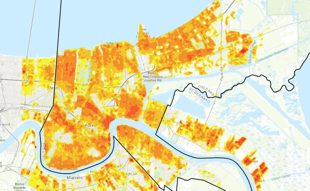
This map of New Orleans from the Trust for Public Land’s National Climate-Smart Cities program shows daytime urban heat island locations in 2023.

Climate & Health
Certain populations are more vulnerable to the impacts of extreme heat.
Young children, older adults, people with disabilities or on some medications may have difficulty adjusting to temperature changes and need help keeping cool and hydrated. Outdoor workers and athletes are more likely to become dehydrated and have a heat related illness. People living in poverty may not have access to A/C or may not be able to afford the cost running it.
Social vulnerability is the demographic and socioeconomic factors (poverty, lack of transportation, crowded housing) that adversely affect communities. Vulnerability can impact the ability to prepare, cope, and recover from a hazardous event.

Climate & Mosquitoes
Changes in heat and rainfall can impact the presence and abundance of mosquitoes. Some of these mosquito species can act as vectors for diseases like West Nile virus and dengue fever.
A longer period of time during the year with high temperatures and abundant rainfall would be favorable to mosquito development and increases the risk of disease transmission.


Contact
Feel free to contact us with any questions.
Email
smichael@tulane.edu
Phone
(504) 352-0919